When Is the Best Time
Hiking to Widgery Cross and Brad Tor is almost always possible even in changeable weather. This short hike is a "hidden gem" and not marked. Best visited and more impressive at the magic hour before sunset if the Dartmoor weather allows a blue sky and sunshine. Avoid hiking here in May during the huge Ten Tors event. Check out the details here.
Parking
There isn't any sign for the walk or the car park. The reason not many people walk to the cross. We marked the minor road on the map below, which leads to the parking site. Coming from Tavistock or Lydford Gorge on A 386, after the Dartmoor Inn (they offer delicious local meals) on the right before the farm stall on the left, turn right into a gravel road.
Shortly afterwards, you have to pass a gate, and after roughly 200 meters, you get to the car park, which, is free. For more information make a stop at the farm stall. They offer the best beef, pasty and good coffee. The owner provides you with lots of information and pictures for hiking in the nearby surroundings. It’s also one of the car parks for the famous Ten Tors hike. Each May, a huge hiking event takes place on Dartmoor for two days.
Weather Dartmoor
The climate is influenced by the Atlantic Ocean. Due to the higher altitude and exposed areas, more extreme climate conditions appear. Much more precipitation occurs on Dartmoor than in the surrounding lowlands. Many rivers emerge on here. The rain gets quickly absorbed by the moor, the reason that the soil is often soaked. Sometimes the weather is notoriously bad, windy, cold, foggy and of course wet! Autumn and winter are the wettest time of the year. Snow can occur in the winter, but it’s not common. Anyhow, sunny days or hours appear. The driest months are in the summer. The summer mean daily temps are below 20°C, but up to 30 degrees are possible.
Best Months to Visit
Location and Tips

It’s a short steep hike always uphill and the same way back. You can already see the cross on the top of the hill from far away.
Usually, the walk may take 45 minutes to an hour for one way. Due to the severe weather forecast, we had been in a hurry and did the whole hike in an hour. The walk is roughly 6 km in total. If there was too much rain before hiking with rubber boots, it is the best choice before you stuck in the bog with your hiking shoes.
In the beginning, you cross the river Lyd on granite stones. In spring, several horses were grazing along the river.
Soon afterwards the ascent becomes steep until the top of Brat Tor and Widgery Cross. The 360 degrees view is stunning even if the whole sky is grey.
Hiking Map by Locus Map App
Return Trail Length: 3.5 km - elevation gain 188 m
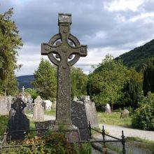
Widgery Cross was erected by William Widgery, an art painter (1822-1893) to commemorate Queen Victoria’s golden jubilee in 1887. The cross is constructed of granite blocks with a height of about 13 feet, and it’s visible for miles. Widgery is the tallest of all Dartmoor granite crosses.
Tip
Nearby are the Two Bridges in the heart of Dartmoor, a popular spot for photographers and tourists.


